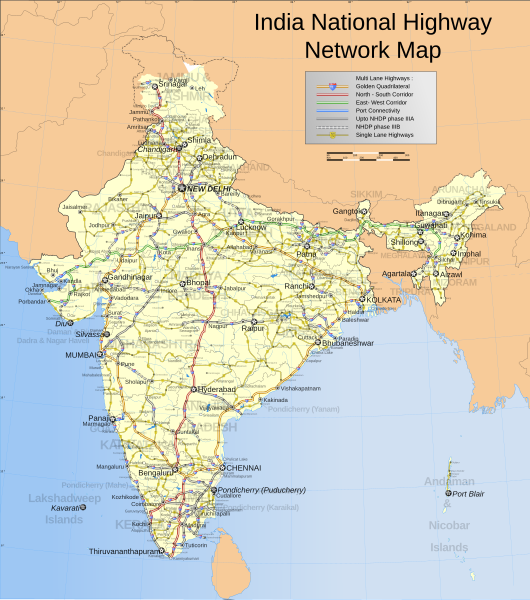
Сурат:India roadway map.svg
Внешний вид

Размер этого PNG-превью для исходного SVG-файла: 530 × 599 пикселду. Рухсатрув: 212 × 240 пикселду | 425 × 480 пикселду | 680 × 768 пикселду | 906 × 1024 пикселду | 1812 × 2048 пикселду | 1639 × 1852 пикселду.
Дайдихьулийсса сурат (SVG-файл, ялтура 1639 × 1852 пиксельду, дуцаву файлдул: 1,11 МБ)
Суратданул тарих
Бас ба кьини/чӀун хьхьичӀсса сурат ккаккан.
| Кьини/чӀун | ЧӀивисса эбрат | Куцру | Гьуртту хьума | ХӀучча | |
|---|---|---|---|---|---|
| хӀакьинусса | 09:58, 2 апрелданий 2021 |  | 1639 × 1852 (1,11 МБ) | JoKalliauer | 1) corrected font-family="'Arial-BoldItalicMT'" and similar to fonts available; 2) put switch at the beginning phab:T279133 3)removed useless clipPaths |
| 13:11, 27 декабрданий 2019 |  | 1639 × 1852 (1002 КБ) | नीलम | File uploaded using svgtranslate tool (https://tools.wmflabs.org/svgtranslate/). Added translation for hi. | |
| 22:04, 18 августрай 2018 |  | 1639 × 1852 (909 КБ) | Cbyneorne | Fixed the spelling of the capital of Mizoram. | |
| 06:14, 2 апрелданий 2007 |  | 1639 × 1852 (909 КБ) | Gmaxwell | Please do not include copyrighted fonts in your SVGs. | |
| 06:13, 2 апрелданий 2007 |  | 1639 × 1852 (909 КБ) | Gmaxwell | Please do not include copyrighted fonts in your SVGs. | |
| 07:33, 9 январданий 2007 |  | 1639 × 1852 (1001 КБ) | Planemad | uttaranchal>uttarkhand, minor color corrections and numbering correction | |
| 17:04, 13 ноябрданий 2006 |  | 1639 × 1852 (1018 КБ) | Planemad | designation for all highways | |
| 10:59, 9 ноябрданий 2006 |  | 1639 × 1852 (865 КБ) | Planemad | updated karnataka city spellings, added nh 110 112 113 114 116 117 119 121 123 153 154 155 224 225 226 227, corrections in north east states | |
| 19:31, 6 ноябрданий 2006 |  | 1639 × 1852 (844 КБ) | Planemad | nh designation markers on nhdp highways, rivers enabled, lightened state names, 3d locators for capitals and major cities, minor corrections north east areas | |
| 18:01, 15 октябрданий 2006 |  | 1639 × 1852 (718 КБ) | Planemad | Included Nhdp phase IIIA, Changed stroke styles for highways, changed marker locators, added state names, included road legend, added more cities and towns, corrections |
Суратданул ишла баву
Хъирив нанисса 1 чӀапӀи ишла дай ва сурат:
Щаллагу дунияллул суратрая мюнпат ласаву
Ва файл ишла дайсар вай викирдал:
- Ишла баву af.wikipedia.org
- Ишла баву as.wikipedia.org
- Ишла баву ba.wikipedia.org
- Ишла баву be-tarask.wikipedia.org
- Ишла баву bh.wikipedia.org
- Ишла баву bn.wikipedia.org
- Ишла баву ce.wikipedia.org
- Ишла баву crh.wikipedia.org
- Ишла баву cv.wikipedia.org
- Ишла баву de.wikipedia.org
- Ишла баву en.wikipedia.org
- National Highways Authority of India
- Roads in India
- Portal:India/Picture of the week, 2006
- Wikipedia:Featured pictures thumbs/06
- National Highways Development Project
- Portal:India/Selected picture candidates/Archived nominations
- Portal:Maps/Selected picture
- Wikipedia:Featured picture candidates/October-2006
- Wikipedia:Wikipedia Signpost/2006-10-30/Features and admins
- Wikipedia:Featured picture candidates/India roadway map
- Portal:India/Selected picture candidates/India roadway map
- Portal:India/Picture of the week 45, 2006
- Portal:India/SC Summary/SP India roadway map
- Wikipedia:Picture of the day/February 2007
- Wikipedia:Wikipedia Signpost/2006-10-30/SPV
- Template:POTD/2007-02-01
- Wikipedia talk:WikiProject Indian maps/Archive 1
- User talk:Planemad/Archive 1
- Portal:Maps/Selected picture/17
- User talk:Planemad/Archive 3
- Wikipedia:Featured pictures/Diagrams, drawings, and maps/Maps
- Portal:India/Selected picture
- User talk:Naveenpf/Archive 2
- Wikipedia:WikiProject India/Recognized content
- Wikipedia:WikiProject India/Main page featured content
- Wikipedia:Graphics Lab/Map workshop/Archive/Apr 2010
- Portal:India/Selected picture/23
- Bibliography of India
- Wikipedia talk:WikiProject Indian roads/Archive 1
- Wikipedia:WikiProject Indian roads/Recognized content
- National Highways and Infrastructure Development Corporation Limited
Ххал дан щала дунияллул аьркин шаву ва файлдул


